• Thanks for stopping by. Logging in to a registered account will remove all generic ads. Please reach out with any questions or concerns.

2024 Wildfire Season

A recent episode of the CBC podcast Quirks and Quarks discussed the significant environmental impact of the 2022 Tonga volcanic eruption. The plume reached a height of 57km...far higher than any other previously recorded and has disrupted the jet stream influencing many of the extreme weather events we've had in the last two years (including to some extent the BC heat waves). It also mentioned that unlike in terrestrial volcanoes the plume of the underwater Tonga eruption consisted primarily of steam from the vapourized sea water which has many times more powerful greenhouse effect than carbon or methane.
The Tonga eruption has been the event almost no-one wants to seem to talk about. There don't seem to be any predictive models for such unusual events. That hasn't prevented people who shouldn't speculate from speculating that they are, in essence, "pretty sure" it didn't have much effect.

I could wish that "experts" would simply say "We don't know" when they can't know.
 
"Different than we're used to" isn't "unpredictable".

I've read about times and places where droughts last for 3 to 7 years, so I suppose it can happen here.

7 year cycles of drought and flood are about par for the course out here. Sloughs filled in the early 2010s, in some cases sinking roads, and stayed that way until just a year or so ago.

There is one local farmer I pass regularly that got his timing wrong. He had a dry field he decided to irrigate. He bought himself a pivot and installed it. That same year that field flooded and stayed flooded for the next five years.

Life in the Palliser Triangle.
 

For reference crews have been on fires pretty much all winter....and new starts still occurring as shown here:

More on the extremely large number of overwintering fires smoldering away in BC and Alberta this year:

 
More on the extremely large number of overwintering fires smoldering away in BC and Alberta this year:

Forecast for now indicates we are on track for a normal spring atleast but would take one change in weather to dry us out come April.
 
The 1980's were particularly dry on the Prairies. No snow at all for two years, sloughs that were never dry were almost dry, trainloads of hay came from the east to help us feed the cattle. Creeks and rivers were dry or almost dry. It was bad. Then the late 80's it started to rain and snow and wouldn't quit at times. Up and down, Up and down.
 
The 1980's were particularly dry on the Prairies. No snow at all for two years, sloughs that were never dry were almost dry, trainloads of hay came from the east to help us feed the cattle. Creeks and rivers were dry or almost dry. It was bad. Then the late 80's it started to rain and snow and wouldn't quit at times. Up and down, Up and down.
Yeah its cycles, right now by mid July the elbow river is dry in calgary, don't really need the bridge across
 
Yeah its cycles, right now by mid July the elbow river is dry in calgary, don't really need the bridge across
There's not much dispute that water levels in down. In Kamloops, a sandbar near the junction of the rivers is exposed that my father believes has not been seen in his lifetime there (50+ years). Of course it's possible that it formed recently, but that's a coincidence too unlikely to be given much weight.
 
There's not much dispute that water levels in down. In Kamloops, a sandbar near the junction of the rivers is exposed that my father believes has not been seen in his lifetime there (50+ years). Of course it's possible that it formed recently, but that's a coincidence too unlikely to be given much weight.
The North Thompson is so shallow from Prichard to Clearwater I don’t see how it won’t be a dry river bed by August if the heat this year is the same as last couple of years. And apparently on the Shuswap the water is 1500 feet back from the normal shoreline in Salmon Arm.
 
I seem to recall, within the last few years, Australia was noticing that many of their fires were starting at the end of dirt roads going into the outback.
 
Here's a pretty neat system that has gotten USAF certification for airdrops and has been tested in Europe with water (and more planned with some additives; basically a palletized system that you can flat pack in, fill the bladders then air drop from a lot of common rear lamp planes. Doesn't replace dedicated water bombers but is a good way to repurpose thousands of existing planes when you need to.

Not something within CAF capabilities atm, but wouldn't be surprised to see this or something similar from companies supporting the provinces. Good way to do things like lay down a fire break, especially in hard to get to areas where there may not be a spot to get a water bomber in to help protect evac routes etc.


The Guardian | Caylym

2nd%20Square.jpg
 
The North Thompson is so shallow from Prichard to Clearwater I don’t see how it won’t be a dry river bed by August if the heat this year is the same as last couple of years. And apparently on the Shuswap the water is 1500 feet back from the normal shoreline in Salmon Arm.
Are you referring to both rivers? Pritchard is on the Thompson east of Kamloops; Clearwater is north.
 
Posted this some time ago.


Aerial Wildland Fire Training Taking Place This Week at Channel Islands Air National Guard Station

The USDA Forest Service, Bureau of Land Management and other federal wildland fire agencies will conduct annual training for Modular Airborne Fire Fighting Systems (MAFFS) personnel at Channel Islands Air National Guard Station, Port Hueneme, April 11-15. The training is being hosted by the California Air National Guard’s 146th Airlift Wing.

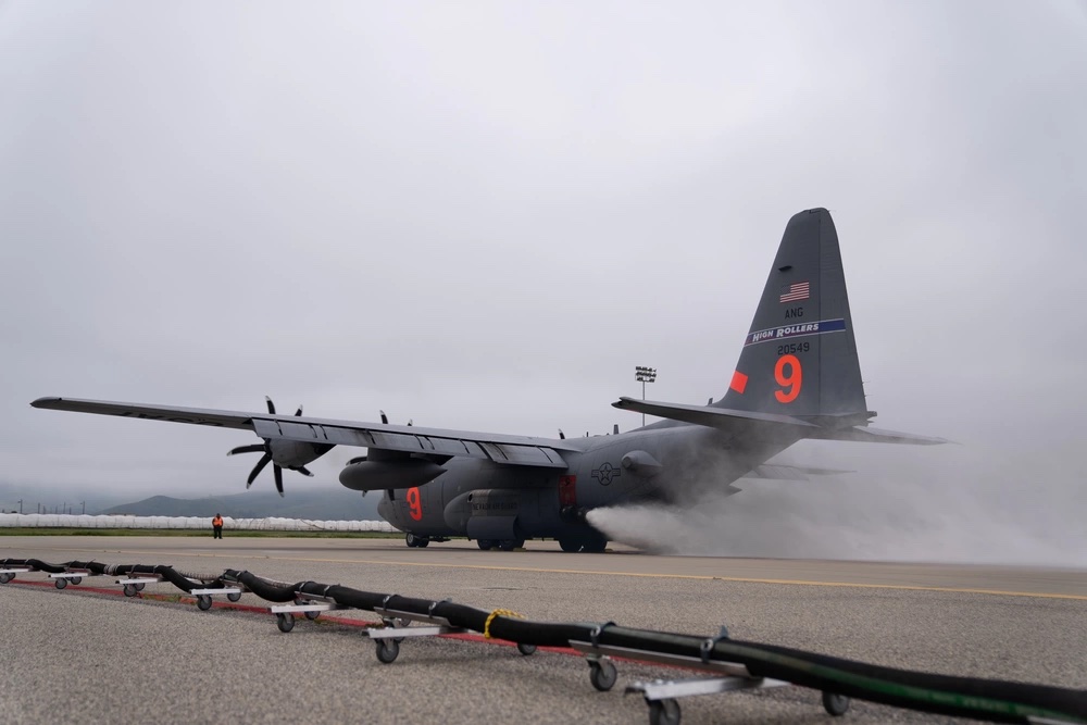
The training will include four military C-130 Hercules aircraft from the Wyoming Air National Guard’s 153rd Airlift Wing and the Nevada Air National Guard’s 152nd Airlift Wing. The training includes classroom sessions, flying and ground operations for Air Force aircrews, civilian lead plane pilots and support personnel from the USDA Forest Service, Bureau of Land Management, other federal agencies and CAL FIRE.

“MAFFS certification training provides the MAFFS community the opportunity to engage not only between the four different MAFFS Wings, but also state and federal agencies,” said Col. Evan Kirkwood, 152nd Airlift Wing Commander. “During this rigorous week of training the Airmen of the 152nd Airlift Wing will strengthen relationships and hone their low-level flying skills in the most challenging environments. I am honored to be the first fully MAFFS qualified Wing Commander in our unit’s history and lead the finest Airmen in the United States Air Force.”

The training session is one of two this spring for the MAFFS program. The California Air National Guard’s 146th Airlift Wing and the Air Force Reserve’s 302nd Airlift Wing, Peterson Air Force Base, Colo., will participate in the same recertification training at Channel Islands ANG Station May 8-12.

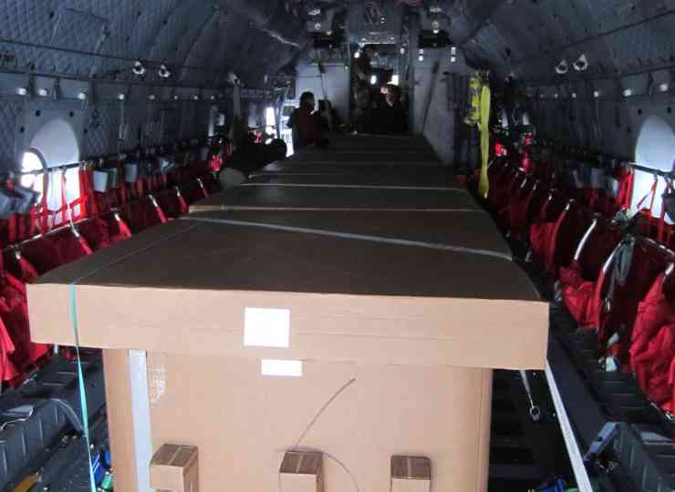
The eight C-130 Hercules aircraft that are part of the program are equipped with the USDA Forest Service’s MAFFS, which can drop up to 3,000 gallons of fire retardant in less than 10 seconds across a quarter-mile line. The system slides into the back of the military aircraft, and retardant is released through a nozzle on the rear left side. MAFFS aircraft can be activated to provide a critical “surge” capability to help slow or stop the spread of wildland fires. MAFFS aircraft are only activated when all commercial airtankers that are part of the national airtanker fleet are fully committed or not readily available.

As part of the training in Southern California, practice water drops will be conducted on some remote portions of the Angeles National Forest. Residents and visitors in those areas may see low-flying C-130 aircraft and smaller lead planes throughout the week.
 
Yes, both. But the North Thompson is especially low.

I grew up in Kamloops (90s-20s) and I remember years where the rivers and the shushwap was really low. Is there historical data available before BC raises the carbon tax to fight river and lake levels?
 
Here's a pretty neat system that has gotten USAF certification for airdrops and has been tested in Europe with water (and more planned with some additives; basically a palletized system that you can flat pack in, fill the bladders then air drop from a lot of common rear lamp planes. Doesn't replace dedicated water bombers but is a good way to repurpose thousands of existing planes when you need to.

Not something within CAF capabilities atm, but wouldn't be surprised to see this or something similar from companies supporting the provinces. Good way to do things like lay down a fire break, especially in hard to get to areas where there may not be a spot to get a water bomber in to help protect evac routes etc.


The Guardian | Caylym

2nd%20Square.jpg
There is already the modular MAFF's units in use by the US National Guard C-130's and Coulson (private fleet) uses a similar system. It's not just about being able to drop once but also the cycle times involved to maintain the wet line.

That being said I haven't seen the cardboard trials yet so learned something new today.
 
I grew up in Kamloops (90s-20s) and I remember years where the rivers and the shushwap was really low. Is there historical data available before BC raises the carbon tax to fight river and lake levels?
In the B.C. Drought Portal, there is a Historical comparison chart, but I think you need to be a Gunner to follow the charts.
 
It's too bad we can't put more resources to watching and tracking intentionally set fires.
It really varies by jurisdiction. Some provinces investigate every fire while others it's only suspicious fires. However when you're dealing with suspicious fires it's not a simple case of "he did it" but also establishing a sufficient case of evidence to be able to charge a person with the crime of Arson...which is federal criminal charges. If you are a small volunteer run fire department I can just about guarantee they don't have the staff, manpower or training to do such investigations and even nationally it's a relatively small pool of people who do wildland fires (which are different from structural or vehicle investigations). For reference the training on wildland fire investigation is one of the few nationally consistent courses and also involves other countries in the standard setting (Aust and USA) but fire investigators are a resource that has been deployed both nationally and internally like other fire specialists depending upon needs.

So some don't get investigated and others that do may show up as arson but no known party. You hope it's a one off anomaly but it's often not and once the patterns start emerging it's easier to start doing tasks like getting the RCMP involved, legal warrants for tracking parties of interest, and/or arresting and charging a party.

The other part is if there are two possible causes it's an undetermined fire. Sucks when you feel like you know the answer but if you're not 100% confident and ready to testify on the stand that was the cause...it's undetermined. There have been some big screw ups in the US with assigning blame based upon incomplete evidence which thankfully hasn't happened yet in Canada as far as I'm aware.
 
I grew up in Kamloops (90s-20s) and I remember years where the rivers and the shushwap was really low. Is there historical data available before BC raises the carbon tax to fight river and lake levels?
Precipitation in southern BC depends a lot on what comes in from the Pacific (to the west), and is substantially affected by El Nino/La Nina. Carbon taxes are unlikely to have much effect.
 
Back
Top